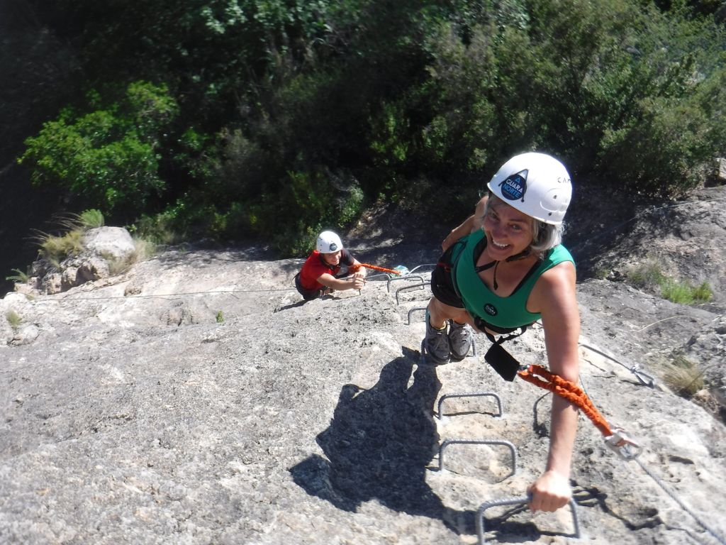
The via ferrata activity in the Pyrenees and Sierra de Guara offers the opportunity to connect with the vertical world of rock for people of all ages, including families and groups of friends.
“A vertical and horizontal route equipped with various materials: pitons, iron rungs, holds, handrails, chains, suspension bridges, and zip lines, allowing safe access to difficult-to-reach areas.” — Wikipedia.
Move where only birds can land and experience new sensations on vertical rock walls, suspension bridges, and zip lines. In Sierra de Guara, you’ll find spectacular via ferratas for all levels—we’ll select the one that best suits your abilities and expectations.
Come and try a via ferrata in the Pyrenees with friends, your partner, or even as a family. Explore Sierra de Guara or the Pyrenees from above—we will guide you safely and provide all the necessary equipment.
This activity can be enjoyed all year round. Spend an exciting and fun-filled day with Guara Norte!
Suitable for a wide range of ages, from young children to adults, each via ferrata in the Pyrenees has its own level of difficulty, so we always choose the best option for your group.
A via ferrata makes you feel free, even while being secured, helping you push your limits, boost your adrenaline, challenge yourself, and build confidence and trust. It is a combination of sensations that, by the end of the activity, will leave you feeling thrilled and accomplished.
Have fun climbing, scrambling, observing, and exploring remote landscapes that would otherwise be difficult to reach. Without a doubt, this is the perfect experience for those who want to enjoy outdoor sports while taking in spectacular scenery. Huesca and the Sierra de Guara offer an unforgettable adventure for your senses.
With Guara Norte, the wide variety of via ferratas will quickly become one of your favorite activities, where fun and excitement are guaranteed.
Check our pricing tables and difficulty levels below.
Contact us to book your experience and discover what a via ferrata is all about—a unique adventure in one of the most spectacular settings.
Don’t forget to bring:
An activity designed for beginners, families, children, and those looking to enjoy the experience without significant technical difficulty or physical demand.
A short approach walk, suspension bridges, some vertical rock sections, plenty of iron rungs, and at all times, breathtaking mountain scenery will be some of the challenges we will face.
Designed for beginners with some experience or those with good physical condition and movement skills. These routes involve some technical and physical difficulty.
Longer routes with gradual progression, taller vertical sections, some technical steps, and an increased sense of height will challenge both our fear of heights and our motivation.
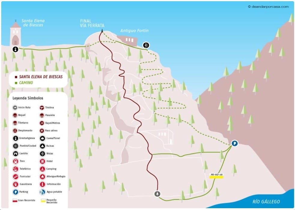
Location: Biescas
Difficulty: K-1
Duration: 1:30 h (Immediate approach, 30-45 min Via Ferrata, 25 min return)
Elevation gain: 95 m
Children: Yes
Beginner-friendly: Yes
Season: All year round
Description:
Legend has it that Empress Helena, now a saint, fled to these mountains to escape Moorish persecution. On her journey, Saint Helena stopped to rest for a moment before continuing her escape to the current site of the hermitage, which was once a cave. According to the story, spiders wove thick webs to hide her from her pursuers. The spot where she rested miraculously produced water, and the rock took the shape of a chair, with her footprints embedded in the ground.
A fountain and a hermitage were later built inside the cave, with the oldest part dating back to the 13th century, although it has undergone several renovations over time.
Today, there are two ways to reach the hermitage area:
A 25-minute pilgrimage trail
Climbing via the via ferrata
The via ferrata consists of six well-equipped steps, relatively vertical but without any difficulty. Some people have attempted the route without safety equipment, which, given its ease, might seem understandable, but it is absolutely not recommended.
Interestingly, the flow of the fountain’s water is believed to reflect the mood of Saint Helena. If the local people misbehave, the water floods the meadow in front of the sanctuary. Fortunately, this water is also said to have healing properties.
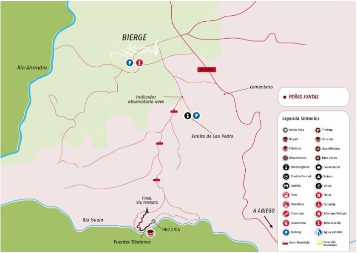
Location: Bierge
Difficulty: K-1
Duration: 1:30 h (20 min approach, 30-45 min via ferrata, 20 min return)
Elevation gain: 80 m
Children: Yes
Beginner-friendly: Yes
Season: All year round
Description:
The best thing about the Peñas Juntas via ferrata is the scenic landscape in which it unfolds. The Sierra de Guara never ceases to amaze with its charming hidden spots. The narrow gorge of the Isuala River, where the suspension bridges are located, is already worth a visit on its own.
The 6 m, 25 m, and 8 m bridges allow us to cross this peaceful river section in a fun and easy way, with an optional dip in the water. The first and second Tibetan bridges are connected by a slightly overhanging section of rungs and an easy descent between boulders, leading to the 25-meter slightly unstable Tibetan bridge.
At the end of the bridges, we reach the actual start of the via ferrata, which can be skipped by taking a trail to the left—some say that the trail is actually harder than the ferrata itself.
The via ferrata poses no difficulty and allows us to safely enjoy this remote corner of the Sierra de Guara. Always climbing to the right, we will reach the eastern summit of Peñas Juntas, marking the end of the route.
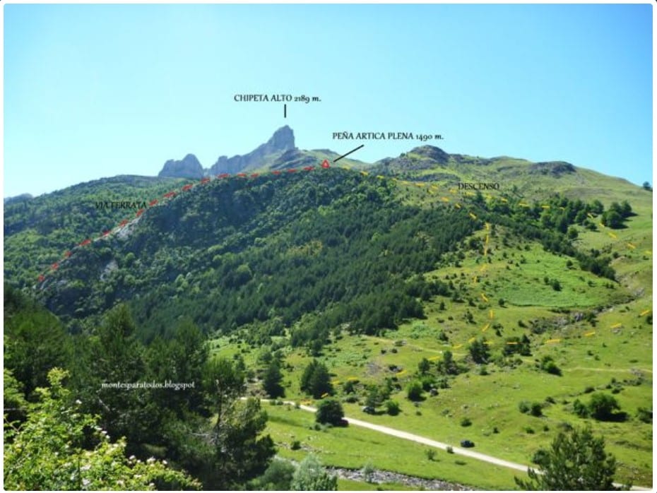
Location: Selva de Oza (Hecho)
Difficulty: K-2
Duration: 2:30 h (10 min approach, 1:30 h via ferrata, 45 min return)
Elevation gain: 212 m
Children: Yes (recommended for ages 10 and up)
Beginner-friendly: Yes
Season: Spring, Summer, and Autumn
Description:
The first section follows a rock wall using iron rungs, though some areas rely on natural rock holds. As the incline decreases and more holds appear, the rungs disappear, requiring scrambling. In this section, some shock-absorbing springs are placed for added security.
Further ahead, the route splits:
Left: The main via ferrata continues.
Right: An alternative route provides an escape option.
This variation ascends slightly before traversing rightward toward a gully, where you descend using natural rock holds (grade II). The safety cable ends at a small step with iron rungs. From here, the descent continues through a steep forested area until the trees thin out. Exiting the gully to the right, you’ll quickly rejoin the approach trail. This alternative is not easier, it simply shortens the route.
The main route continues climbing through an eroded rock section with natural holes that make the ascent easier (grade II-II+). The wall gradually becomes less steep, to the point where you can climb using friction without your hands, unless you choose to hold onto the safety cable.
The route ascends toward the eastern ridge of the peak. Near the end, you’ll encounter a few steps (maximum grade III). The safety cable ends after 140 meters of elevation gain, and from there, you follow a marked crest trail leading to the summit of Peña de Artica Plena (1,490 m).
The best part of this via ferrata is its stunning surroundings. If going with children, it’s recommended for ages 10+, and in winter, it is only suitable for experienced mountaineers due to snow conditions.
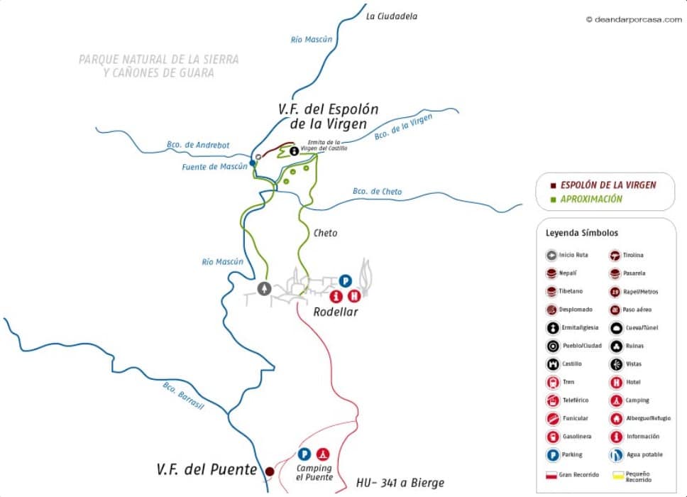
Location: Rodellar
Difficulty: K-2
Duration: 2 h (40 min approach, 50 min via ferrata, 45 min return)
Elevation gain: 146 m
Children: Only autonomous climbers
Beginner-friendly: Yes
Season: All year round
Description:
The Espolón de la Virgen via ferrata is located in a privileged spot in Sierra de Guara, where cliffs and ravines were once accessible only to climbers and canyoners. This new route allows adventurers to enjoy the steep walls of the Sierra on a trail that is not overly difficult.
During the approach, which follows the bed of the Mascún River, expect to get your feet wet, as the path merges with the river. The sounds of swimmers blend with the efforts of climbers attempting their ascents.
The via ferrata begins with a fast, well-equipped ascent that gradually becomes more challenging as it leans leftward. After this first section, the route continues with chains leading to the next vertical climb. This section follows a rock spur, giving the via ferrata its name.
The result is an impressive 8-meter ascent that leaves climbers suspended over the void. Despite the exposure, this section poses no major technical difficulties beyond the height sensation. The climb ends on a small plateau, offering a perfect resting point with stunning views. From here, you can admire the Andrebot Canyon, the Mascún Superior, and La Ciudadela, as well as the climbing walls where daring climbers tackle seemingly impossible routes.
The final stretch is an easy climb leading to the summit, where you’ll find the Hermitage of La Virgen del Castillo.
Location: Broto
Difficulty: K-2
Duration: 1:15 h (Immediate approach, 35 min via ferrata, 35 min return)
Elevation gain: 120 m
Children: Yes
Beginner-friendly: Yes
Season: Spring, Summer, and Autumn
Description:
The via ferrata consists of several short sections, each with a name based on its characteristics: La Selva, La Visereta, La Red, El Chorré, El Anfiteatro, Las Gradas, La Losa, La Ceja, El Estrecho, and La Canal. The segments are very short, so they can be easy to mix up.
The route begins with a metal bridge, similar to those used in construction sites, already equipped with a safety cable. Some sources mention that this bridge may soon be replaced by a two-meter-long Tibetan bridge.
Next comes a long traverse along a narrow path between rock and vegetation—hence the name La Selva. This section is almost horizontal, making it perfect for beginners to get familiar with via ferrata techniques.
The next part, called La Visereta, is a vertical section equipped with a 3-meter iron ladder, which is easy to climb and ends in a curious way.
From this point onward, water flows through the area, so caution is needed to avoid slipping. The next step is another iron ladder, leading up a slightly overhanging vertical section. Despite its steeper incline, it remains easy to climb and is longer than the previous one. To the right, a small waterfall can be seen, originating from a drain or water diversion system located near the top of the ferrata.
The following section is a muddy terrain with a gentle incline, where the main challenge is avoiding slips. Towards the end, it transitions into small ledges with iron rungs embedded in the ground for easier progression. These zones are referred to as El Anfiteatro, Las Gradas, La Losa, and La Ceja, likely named after the final rocky steps.
The last part, known as El Estrecho and La Canal, is a narrow gully equipped with rungs and a chain to assist with progression and prevent slipping. Despite its name, the passage is not too tight. It features an original wooden log with carved steps, used to overcome a small ledge.
This entire section is easy and fun, making it a great choice for beginners and families. The end of the via ferrata is marked by a small irrigation channel and a water distribution system, which is also the source of the waterfall seen earlier during the ascent.
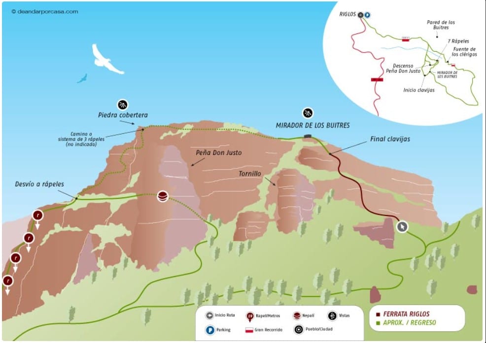
Location: Riglos
Difficulty: K-2/3
Duration: 4 h (1 h approach, 45 min via ferrata, 2 h return)
Elevation gain: 440 m
Children: Only autonomous climbers
Beginner-friendly: Yes
Season: All year round
Description:
Iron pegs instead of rungs. It may not seem like a big difference, but in practice, ascending using small iron pegs instead of the large, comfortable ferrata rungs feels quite different. This, combined with the spectacular setting of the Mallos de Riglos and the easily visible vultures, makes the climb to the Vulture Viewpoint (Mirador de los Buitres) a truly enjoyable experience.
The first section of pegs has no safety cable, but it quickly leads to a nearby ledge that curves left, marking the real start of the route. The ascent begins with an inclined rock slab, leading up through a tree-lined section to another ledge. From here, the route consists of alternating vertical sections interspersed with small ledges.
As the route progresses, there are a few steep, exposed sections. The second part of the ferrata significantly increases the sense of height and exposure.
At this point, the small viewpoint at the summit comes into sight on the left-hand side. The final section of pegs features a small roof, which is easy to climb thanks to well-placed pegs and a safety cable.
One of the highlights of this excursion is that every part of the route is enjoyable. The iron pegs feel like the icing on the cake.
Once at the viewpoint, the descent begins, offering multiple route options. If you choose to descend via Peña Don Justo, you’ll experience a well-equipped path that almost feels like a second via ferrata. Along the way, you’ll pass by the Piedra Cobertera, with its breathtaking exposure, and near the massive rock formation known as El Tornillo, just before the final section of the descent.
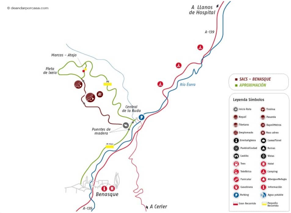
Location: Benasque
Difficulty: K-3
Duration: 2 h (10 min approach, 1:15 h via ferrata, 35 min return)
Elevation gain: 350 m
Children: Only autonomous climbers
Beginner-friendly: No
Season: Spring, Summer, and Autumn
Description:
The Sacs via ferrata follows a small mountain stream and finishes near Collado de Ixeia, a low-altitude peak next to the Ésera River.
The route starts off promisingly, with a fast, low-angle ascent equipped with climbing holds. However, the incline quickly eases into gentle slopes secured with safety cables and a few chains.
At the end of this easy but exhausting ascent, the real challenge begins. The main rock face rises vertically over the void, with iron rungs leading upward and diagonally to the right. Here, climbers face their first real difficulty—the rungs pull the body toward the rock face, requiring strong arms and a relaxed posture to maintain balance.
After navigating two highly exposed ledges, the route continues upward, exiting the gorge and leaving behind the steepest and most demanding section. This leads to a small, peaceful plateau shaded by an oak tree, offering a perfect resting spot.
The final stretch consists of several vertical steps, leading to a slightly overhanging section that marks the final challenge of the Sacs via ferrata. From the summit, climbers are rewarded with breathtaking views of the Benasque Valley, the Ésera River, and panoramic sights toward Maladeta (3,308 m) and Aneto (3,404 m).
Location: Sesué (Benasque)
Difficulty: K-3
Duration: 1 h (5 min approach, 40 min via ferrata, 20 min return)
Elevation gain: 237 m
Children: Only autonomous climbers
Beginner-friendly: No
Season: All year round
Description:
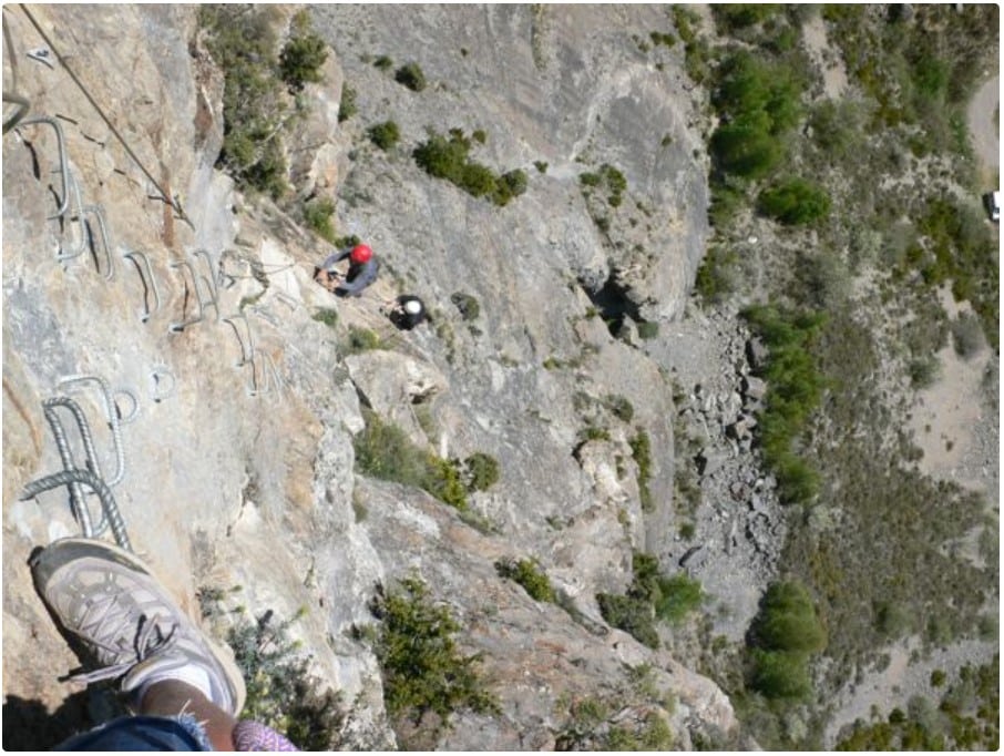
This ingeniously designed and well-equipped via ferrata makes the most of the Castellaso’s elevation gain, offering a varied and highly aerial route.
The initial section serves as a perfect warm-up. In the final steps before reaching the vertical section, there are no iron rungs—only a safety cable, requiring climbers to find natural rock holds to progress.
Once on the vertical wall, the iron rungs reappear, as progression without them would be very challenging. This section features several short overhangs (around four), each more exposed than the last. The ferrata climbs straight up, almost like a direct alpine route.
The overhanging sections, though short and well-equipped, demand good arm strength and composure.
The route ends on a grassy area, where the ferrata continues leftward over a small, easy step leading to the summit of Castellaso—a natural viewpoint overlooking the Ésera River Valley and the Pyrenees.
Localización: Broto
Dificultad: K-3
Duración: 2 h. (5′ aproximación, 1:30 h. de Vía Ferrata, 25′ retorno)
Desnivel: 126 m.
Niños: Solo autónomos
Iniciación: No
Época: Verano y épocas de NO lluvias
Descripción:
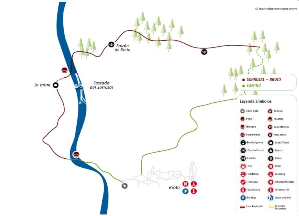
Si una cosa destaca en Broto en pleno mes de mayo es la cascada del Sorrosal que baja cargada y furiosa con el agua del deshielo. Ahora podemos disfrutar de cerca la cascada y el barranco del Sorrosal, gracias a la vía ferrata que discurre paralela a su recorrido. El entorno de la cascada e inicio de la vía es un anfiteatro natural lleno de plegadas que explican el proceso de formación de los Pirineos. Las formas geométricas de la roca junto al ruido de la cascada llegan a convertir el lugar en algo hipnótico.
El inicio de la ferrata es bastante peculiar, como en general todo el material usado en la vía. Una escalera-puente nos ayuda a superar el primer resalte. A partir de aquí ascendemos en busca de la cascada a través de grapas y clavijas hasta que llegamos a la altura del primer pozo. Aquí comprendemos el porque esta vía permanece cerrada durante el invierno. La piedra es inestable y el riesgo de desprendimientos es mayor a causa de la acción del hielo.
La instalación de 5 largas escaleras en este tramo, no es porque sí. Aunque la solución es aparatosa es la única segura en este tipo de roca. Vamos subiendo con la cascada a nuestro lado, nos internamos en la pequeña gruta, la cruzamos sin dificultad y vamos a parar al interior del cañón, al origen de la cascada. Avanzaremos por el interior del barranco con la ayuda de grapas y un pequeño puente de madera.
Después de un par de resaltes salimos a mano derecha y nos internamos en la vegetación, para recuperar altitud a través de unas grapas hasta el Balcón de Broto.
Localización: Foradada del Toscar
Dificultad: K-4
Duración: 2:45 h. (15′ aproximación, 2:00 h. de Vía Ferrata, 35′ retorno)
Desnivel: 240 m.
Niños: No
Iniciación: No
Época: Todo el año
Descripción:
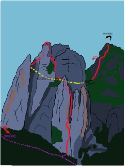
La vía se divide principalmente en tres tramos. El primero es el más vertical y el que supera más desnivel, sube un espolón y por una estrecha canal, sello distintivo del itinerario.
En el segundo tramo descenderemos parte de lo subido por la cara oculta de la pared hasta llegar a la pasarela, acceso al tercer tramo, opcional y mucho más fácil que lo hecho hasta el momento. Con buenas vistas a las agujas por las que transcurre la ferrata.
Localización: Beranuy
Dificultad: K-4
Duración: 3:30 h. (5′ aproximación, 2:30 h. de Vía Ferrata, 45′ retorno)
Desnivel: 355 m.
Niños: No
Iniciación: No
Época: Todo el año
Descripción:
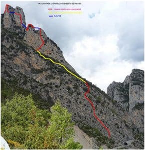
Los primeros metros son un simple acceso al primer sector de esta ferrata que podemos dividir en cuatro tramos. También la podemos definir como dos ferratas situadas una sobre la otra, la de abajo tiene una dificultad media y al alcance de la mayoría, una vez terminada podemos descender hacia la derecha por una senda muy empinada o continuar andando hacia la ferrata superior recomendable solo para expertos.
Primer sector
Tiene un desnivel entorno a los 100 metros desde la carretera, discurre por un muro donde alternamos zonas muy verticales con otras más suaves, aunque en algún punto hay que usar la roca, el equipamiento es abundante y de calidad.
Segundo sector
Llegamos a una amplia faja pedregosa que recorre en diagonal la mitad del monte. Hacia la derecha bajaríamos al coche por una senda escarpada, a la izquierda continúa la vía por un sendero donde pronto acaba la línea de vida. El terreno es empinado, subimos hasta ver un pequeño abrigo ennegrecido y el inicio del tercer tramo.
Tercer sector
El inicio nos deja claro la dificultad de lo que nos resta de vía, subimos por un muro muy vertical con varias zonas en ligero desplome. Nos acercamos a una pequeña aguja que evitamos por la izquierda llegando al primer puente tibetano, para los pies dispone de doble cable y placas. Solo nos quedan unos metros hasta la cima de la Aguja 1313 m.. El desnivel ronda los 90 metros.
Cuarto sector
Desde la cima el cable continúa por una chimenea por la cara oeste, bajamos unos 10 metros por unas grapas muy separadas y flanqueamos en busca del segundo puente al que accedemos por el tronco horizontal de un árbol. Cruzamos sobre la canal de escape y afrontamos el espolón de la primera punta de la Aguja de la Croqueta. Este sector quizás no sea tan vertical como el anterior pero si igual de duro y vertiginoso, vamos alternando flanqueos hacia la izquierda con subidas. Llegamos al tercer puente tibetano donde los pies tienen solo un cable, de esta forma hacemos un espectacular cambio de pared hacia la punta principal de la Aguja de la Croqueta 1396 m. de altitud. Desnivel 90 metros.
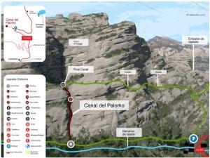
Localización: Vadiello
Dificultad: K-4
Duración: 2:30 h. (5′ aproximación, 1:35 h. de Vía Ferrata, 35′ retorno)
Desnivel: 100 m.
Niños: No
Iniciación: No
Época: Todo el año
Descripción:
El primer tramo se encuentra al inicio justo después de superar un par de pequeños resaltes, es una chimenea tumbada y resbaladiza muy vertical. Con nuevas clavijas es más fácil superarlo.El segundo es otro tramo muy vertical por el que avanzaremos con la ayuda de las clavijas y por oposición. En la parte media es difícil encontrar una buena posición para seguir subiendo…
Ya casi a la salida, cuando la canal se va abriendo, encontramos el paso más difícil de todos, una cascada lisa y resbaladiza con clavijas a lado y lado y una entrada ligeramente desplomada. Con tranquilidad y estirándonos lo suficiente saldremos del resalte para afrontar un último paso estrecho y desplomado que es la guinda final.
Adentrarse al canal del Palomo es en definitiva impresionante de inicio a fin. Es fácil ver en la badinas pequeños tritones, señal de la pureza de las aguas. Éstos están protegidos y se prohibe entrar en las aguas durante todo el año. Las formas sinuosas y la verticalidad de la canal nos van preparando para el escenario final, un alto circo ciego barrera infranqueable y nido privilegiado de rapaces y otras aves características de los Mallos de Ligüerri.